Originally Published in the IAMC Newsletter, December 2012
Editor’s Note: This article appeared in the September 6, 2012 issue of the Idaho Statesman and is reprinted here by permission of the author.
STORY AND PHOTOS BY ROGER PHILLIPS — [email protected]
We accelerated onto the Interstate and looked over at the Boise Foothills cloaked in smoke as thick as coastal fog. Wildfires were burning throughout the state like Roman candles randomly placed on an Idaho map, but we weren’t too concerned.
We had planned our motorcycle ride months ago and scheduled time off from work, and we weren’t going to abort our trip over a few wildfires. Through them, around them, beside them or in front of them, we didn’t care. We were on motorcycles that could go nearly anywhere.
Our trio, brothers Dave and Mike Heimer of Boise and myself, had a simple plan: ride the Magruder Corridor — a 100-miles-of-dirt-and-gravel road in Montana and Idaho that divides the Selway/Bitterroot and Frank Church wildernesses.
The secondary goal was to avoid pavement as much as possible getting to the Magruder Corridor on what became a 960-mile odyssey through Idaho’s backcountry.
COME ALONG FOR THE RIDE
Finding dirt and gravel roads in Idaho isn’t a challenge. Navigating them and keeping your bike and body intact is another matter.
The pavement dissipated about 20 miles from Boise on Blacks Creek Road as we rolled toward Prairie. It was the first reel in a seemingly endless loop of postcard scenery as we dropped into the rugged black-rock canyon of the South Fork of the Boise River.
We stopped in Prairie for a quick break and hit our first road block. The road to Pine was closed because of the Trinity Ridge Fire.
Fire detours were not unexpected, so out came the map. We replotted our route back into the South Fork canyon, across Anderson Ranch Dam, up to U.S. 20 and on to Fairfield.
You have to be careful whipping out a map in a parking lot in Fairfield, or any other small town in Idaho. It attracts helpful people like a bear to a dumpster full of donuts.
A gal in a Jeep insisted on leading us north of Fairfield toward Couch Summit, where we would tie into our original route on back roads into Ketchum.
RUN WITH WHAT YOU BRUNG
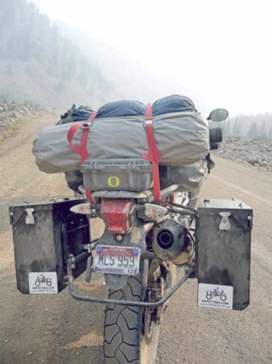
It’s an old saying that applies to adventure motorcycle riding. Your bike is your transportation and pack animal. It’s a tricky balance between bringing enough to be safe and comfortable and not being overloaded, which makes your bike harder to handle.
Adventure bikes are big and heavy. Our stable included a KTM 990 Adventure, a Triumph 800 Tiger XC and a venerable Kawasaki KLR 650. They weighed in around 500 pounds unloaded, give or take 50 depending on the bike.
Add a week’s worth of camping gear, clothes, food, tools and spare parts and they gain weight quicker than a 4-H hog before the county fair. One minute you’re riding them, and the next you’re wrestling them.
There’s also the matter of terrain. Idaho’s backcountry is steep, rugged and unpredictable. Back roads can vary from graded and smooth to cobblestone rough. Even if you know your route, which we didn’t, things are constantly changing because of weather, traffic, falling rocks, downed timber and other hazards.
OVER THE HILLS AND INTO SUN VALLEY
We crossed out of the Boise River drainage and into the Wood River drainage. Our trip was guided by landscapes as much as roads. We were constantly crossing out of one river system and into the next, or bouncing in and out of a major drainage, such as the Salmon River.
The landscape wasn’t dramatically different between the Boise River and Wood River drainages, but we could tell we were getting close to Ketchum. The faded, peeled, shot-up, or completely missing Forest Service road signs suddenly looked like they came straight out of a craftsman’s workshop.
We followed Warm Springs Creek past the million-dollar cabins to Ketchum and Sun Valley. It took us most of the day to get there, and we were dusty and sweaty as we topped off our tanks and stopped at a deli in Sun Valley for a drink.
Among the pressed shorts, designer shades and polo shirts, it looked like the ruffians had arrived. Sun Valley used to make me feel weird. It just seemed to cater to a crowd to which I didn’t belong.
But people there have always been friendly, so I think the hang-up lies within. I still feel a little out of place there, but not unwelcome, if that makes any sense.
ANOTHER SUMMIT BEFORE CAMP
I jokingly asked if we could skip camping that night, stay at Sun Valley Lodge, take in an ice skating show, eat at a fancy restaurant and cap it off with a nice bottle of wine. It didn’t get much traction. That’s not how the ruffians roll.
We left Sun Valley and headed north over Trail Creek Summit. Even swathed with smoke, it was beautiful. The broad, U-shaped valley with a meandering, willow-lined creek in the bottom made it hard to keep my eyes on the steep, winding road.
I’d never traveled over Trail Creek Summit, and it was the first of many scenic surprises.
I was the unofficial ring leader because I had plotted our trip with the caveat that detours were allowed in any direction for any reason.
We were heading for Copper Basin, but Mike took us on a detour into nearby Wild Horse Creek.
Dave and Mike’s dad, John Heimer of Boise, has been traveling around Idaho for decades, and he describes Wild Horse Creek as one the most beautiful places in Idaho, but it was shrouded in a smoky haze when we arrived.
In the morning, the sky cleared and the creek swirled and tumbled beneath the slate-gray Pioneer Mountains looming in the background. It was tough to argue with Papa Heimer.
BEAR RACING AND OTHER ADVENTURES
I’m not sure if the term “adventure riding” was borne by motorcycle adventurers or Madison Avenue types who came up with a clever way to sell expensive motorcycles.
Every person has his or her definition of an adventure, but to me it simply means you can expect plenty of surprises, you must constantly adapt, and there’s a reasonable chance the trip will fail to end well.
We checked off the “plenty of surprises” box when a black bear rose from the sagebrush and ran parallel to Dave’s motorcycle on the loop around Copper Basin.
I was in the lead and oblivious to Dave’s honking and flashing lights trying to get my attention. Dave stopped his bike and snapped a photo before the bruin disappeared into a draw.
Any debate of Wild Horse Creek being the most beautiful place in Idaho had to be reconsidered after traveling through Copper Basin.
A pair of cowboys and several dogs herded cattle with a panorama of mountain peaks surrounding them like a over-exaggerated theater set.
This went beyond scenery. It was the story of the West brought to life, and it was as moving as the finale of a cowboy movie.
“They’re riding horses, we’re riding iron horses,” Dave said.
We left Copper Basin and headed toward Mackay. I got ahead of the Heimers and took a break at the top of a ridge separating Copper Basin from Mackay.
This was road-runner country. You could see a plume of dust kicked up by a rider from a mile away, but the air was clear, and no dust rose from the road that undulated across the rolling sagebrush terrain that stretched for miles.
I have as much patience as a Labrador retriever sitting in a duck blind waiting for shooting hours to start on opening morning, but aside from that, waiting gets my mind wandering and worrying.
Our internal clocks know roughly how long it takes for a variety of common stops, including readjusting cargo on the bikes, shedding or adding a layer of clothing, taking a photo, watering a sagebrush, watching a critter, etc.
This break was taking longer than all the above, which made me nervous. I ran down the mental checklist of reasons to stop, and got hung up on a breakdown or a crash.
I slowly rode back so we didn’t meet on a blind corner, and eventually reconnected with Dave and Mike.
Mike had “lawn darted” into a ditch at about 35 miles per hour. Mike and the bike survived, but he was hobbling, and his foot was swelling like the federal deficit.
CROSSING A GOAT TRAIL ON ONE LEG
We dropped into Mackay and had one of many fine meals in small-town Idaho. Either the food is better there, or miles and hours on dusty roads make a guy hungrier. Either way, they were welcome rest and refuel stops.
Mike gobbled Ibuprofen and gave his foot a rest. He could still ride, though somewhat painfully. We didn’t know the extent of his injury, but he wanted to keep riding.
We continued toward our next camp, but another set of mountains stood between us and there.
Part of the fun of adventure riding is picking a squiggly line on the map and going for it.
Between my map reading and Dave’s GPS, we went west from Mackay and ended up on a goat trail. Not sure of its real name, it was a Jeep road that followed a creek, then crossed the creek, then went up and down steep hills with lots of loose dirt, chunky rocks, cow pies, ruts and other trail gremlins.
Then it repeated that sequence numerous times.
Dave and I struggled to keep our bikes upright and pointed in the right direction.
Mike didn’t have the luxury of standing on the foot pegs because of his sore, swollen foot. He got up close and personal with the sagebrush a couple times.
We felt bad for Mike and helped him pick up his bike after each crash, but that was all we could do.
The map showed and the GPS confirmed the goat trail went where we wanted to go, but they didn’t show what condition the road was in.
Would it get worse or better the farther we went? Once you’re committed to a goat trail, it’s a tough call. Turning around is brutal because you have to go back through the rough parts you just endured, and after that, you still have to find another route.
It’s easier to convince yourself the better road lies ahead. The devil you don’t know always seems a little more angelic.
Mike persevered, but not without some pain, sweat and cursing.
Goat trail, crashes, heat stress, and fear of the unknown, more boxes checked off the adventure checklist.
MORE SMOKE AND SCENERY
We mostly had a reprieve from the smoke on the second day, but as we descended into the East Fork of the Salmon River, it covered the valley like a low-hanging orange cloud.
I glanced over and a cow moose trotted along the creek the road followed. It easily could have turned and ran away, but it kept its pace. What’s with these wild animals trying to race us?
It felt like were riding into the flames as we descended into the heat of East Fork of the Salmon River near Clayton. We tried to ride with our face shields up, but our eyes stung even while wearing sunglasses. After stopping, we saw gray snowflakes settling on our motorcycles and realized ash was getting in our eyes, not just smoke.
We settled for the night in a campground near the Salmon River, and after about 8 hours in the saddle, it felt good to be on a picnic table bench instead of a motorcycle seat.
We got up the next morning and Mike’s foot was still sore and swollen, but he could ride.
Dave and I assured him there were no goat trails ahead. I didn’t know for sure, but the squiggly lines on the map looked considerably bolder.
We got out of camp early. I’m a morning slacker. Dave is a Marine, which means he sits still about as well as a squirrel that just raided a Starbucks dumpster.
Nobody wanted to be the guy holding up progress, so it was a silent race to see who could break camp and load his bike the quickest.
Sometimes we were too quick for our own good. Mornings in the mountains are chilly, even in August.
I had to layer on more clothes, and I was close to wearing all the layers I had as we cruised up the Salmon River toward Sunbeam.
I eagerly awaited Goldilocks time when I could ride without getting chilled or sweating.
But with temperatures swinging 30 or 40 degrees between morning and afternoon, Goldilocks time was usually temporary and fleeting.
Our third day was through more amazing backcountry starting at Sunbeam and proceeding down the Custer Motorway to Challis.
The motorway is a drive-by history lesson of the Custer mining community complete with restored buildings and lots of artifacts from the mining days.
There’s also a series of interpretive signs along the route that are actually interesting and lack the usual horror stories about someone getting massacred at that spot 150 years ago.
Note to the folks who make the road-side signs along highways. What’s with the buzz kills? Would it hurt to put a sign at a picturesque place that says something like “In 1968, a newlywed couple camped at this spot in a VW bus, drank a bottle of wine and conceived the first of many happy children.”
Just a suggestion.
The Custer Motorway wound through the timber and emerged into the red-rock country of Challis.
The transition was swift and the contrast abrupt. Timber, sagebrush, red rock. From there, it was a quick buzz up the U.S. 93 to Morgan Creek Road, over Morgan Creek Summit and down into Panther Creek.
The road follows Panther Creek, and we could see the canyon walls close in. They got steeper, rockier and more rugged and the water wilder as it tumbled through rapids.
The sky also got dark with smoke until everything took on an creepy orange hue. If this were Hells Canyon, instead of Panther Creek, I would have turned around out of a fear a red guy with a pitchfork would step out.
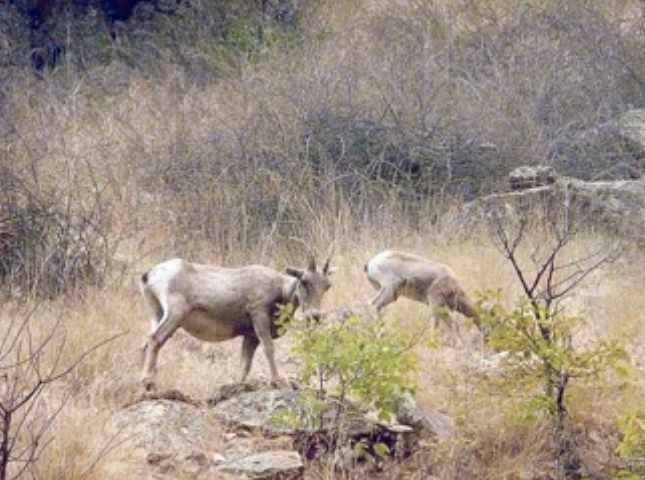
Dave was out front as we rode down Panther Creek, and he skidded to a stop in the middle of the road, jumped off his bike and ran down the road with his camera in hand.
It could mean only one thing: Bighorns. They were crossing the road after drinking in the creek.
“They’re the toughest animal in North America to hunt, and I almost took out a herd of them with my motorcycle,” he said.
Fortunately, a collision was avoided, and we watched the sheep graze on the hillside.
We arrived where Panther Creek meets the Salmon River canyon; the heat, smoke and dust took its toll. I was ready for a rest.
We stopped at the Shoup Store for a drink. Our choices? Beer or iced tea. Since we still had some miles ahead, we opted for the iced tea.
The owner grabbed a giant glass jar off the rail in front of the store and filled three plastic glasses.
Tea never tasted so good. In fact, if you want the best iced tea in Idaho, I recommend the Shoup Store.
The fires hadn’t just socked in the canyon with smoke, it had blocked the next leg of our route up Spring Creek and into Montana.
ADVENTURE LODGING
Instead of going up Spring Creek, we continued up the Salmon River to North Fork and stopped for dinner.
One of the beauties of motorcycles is they can cover miles of backcountry road remarkably fast. When you start to get hungry, the next town is usually a twist of the throttle and minutes away.
We ate dinner at North Fork General Store and Cafe and stared out at smoke so thick it made the afternoon look like dusk. We’d been on the bikes all morning and afternoon, and the next camp was still a ways down the road.
We asked the waitress about the motel that adjoined the restaurant and got a room with four bunk beds for $75 a night, which included breakfast.
Part of adventure riding is dealing with unexpected situations and adapting, even if that means chicken-fried steak smothered in gravy, a hot shower, clean sheets and breakfast.
AND THEN THERE WERE TWO
After two days and a handful of Ibuprofen, the swelling in Mike’s foot showed no sign of subsiding, and it was taking on an ugly purple hue.
The whole Magruder Corridor was still ahead, and Mike made the “heartbreaking” decision to turn back. He called ahead for someone to meet him with a pickup halfway and headed south while we rode north.
Montana’s blue skies and green trees never looked so good. The sky was a clear as a spring day as we cleared Lost Trail Summit on U.S. 93.
We took advantage of smooth pavement and Montana’s liberal attitude toward speed limits. Since I can’t remember what the speed limit was on that stretch of highway, I can neither confirm nor deny exceeding it.
But I will say, Dave was out front the whole time, and his time on sport bikes, aka crotch rockets, definitely showed on the twisty mountain road.
Crossing Lost Trail Summit at an altitude of 7,000 feet made me once again re-examine my definition of summer weather. Adding the wind chill from riding at highway speeds, and it was downright cold.
SCENERY OVERLOAD
The Magruder Corridor was the focal point of our trip, and it only took us 500 miles and four days to get there.
We left the highway at Conner, Mont. and headed west onto the start of the corridor, and to our surprise, the pavement continued another 25 miles.
At this rate, we would be through the corridor by lunch. So this was the notorious Magruder Corridor?
Not to worry, we were soon under a canopy of pines and firs with the road so narrow, brush branches in the barrow pit wanted to high-five us at every corner.
We passed the Magruder Ranger Station and crossed Deep Creek, which is a tributary of the Selway, and rode up to the ridges. There we found long stretches of backroads that seemed to be built with recycled bowling balls.
I stood on the foot pegs, aimed for the line of least resistance, bumped the throttle to gain a little momentum and bounced through the worst of it. Then I relaxed my tense muscles for a moment before attacking the next bony section.
Ahh, so this is the notorious Magruder Corridor.
We crested a rise and saw distant wisps of smoke rising from the forest, and we knew they weren’t campfires. The ones to our left and right weren’t an issue. But our handlebars and front tires pointed like gun sights toward another one.
BURNT KNOB LOOKOUT
If the Magruder Corridor was our destination, Burnt Knob lookout was a destination within our destination.
Dave had seen photos of it on an ADV Rider, an adventure riding Internet forum, and wanted to take a short detour to check it out.
Visiting lookouts has long been one of my hobbies. I’ve yet to see one that didn’t have a spectacular view.
But somehow, the lookout was elusive. It wasn’t at Burnt Knob Creek, and it wasn’t at Dry Saddle, which had phenomenal, 360-degree views.
Ironically, it was the fire that led us to the fire lookout. We followed the brown dirt road snaking across the timbered ridge toward a plume of smoke, and there was a sign saying “Burnt Knob Lookout 1.5 miles.”
We headed up, and the rocky and deeply-rutted road was a greater challenge than expected.
Dave crashed in the first 200 yards, and I squeezed by him and found a flat place to park and help him pick up his bike.
The impact popped the pannier off his bike and broke the latch that attached it to the frame. He used a strap to reattach it, and we continued uphill.
If the Magruder Corridor lived up to its reputation as a rough road, the leg up to Burnt Knob exceeded it.
It pushed our limits. We clawed up the hill, and rounding the last bend, my pannier caught a rock and I bit the dust. My front brake lever snapped like a twig, and my panniers were comically or horribly contorted by the crash.
When we got to the lookout, we realized it was unmanned, which explained the brutal road. We also discovered that from the fire lookout, we got a really good view of trees erupting into flames.
A little too good, in fact. The fire was making its afternoon run; we roughly calculated the direction it was traveling and decided it was too close for comfort.
We were now limping on two injured bikes and wounded egos, and we still had to get down the same nasty road that caused us both to crash. There were no guarantees we wouldn’t repeat our performance.
OVER AND OUT
Going down proved easier than going up, but I was now without my front brake because I forgot to bring spare levers.
It was a stupid and inexcusable error on my part. Had I fallen on my left side instead of my right, I would have broken the clutch lever, and my ride would likely have ended there.
It won’t happen again, and I learned the value of those handlebar guards I had earlier written off as too expensive.
Whether it was the previous days of epic scenery, not having Mike along, the crashes, or just eventual fatigue of long days in the saddle, we wanted off the Magruder.
The plastic timer popped; we were cooked.
We continued to Red River, which is the official end of the corridor.
The road is a fantastic, rugged, backcountry trip that lives up to its adventurous reputation.
We rolled into a restaurant/grocery store in Elk City for dinner.
Dave called Mike to check his status. Despite the difficult decision to abort the trip, it was the right one. He’d broken his leg in the crash; X-rays showed a cracked fibula.
We later learned the name of where he crashed was Burma Road. DECLARING
VICTORY AND PARTING WAYS
Dave and I camped beneath tall pines along Crooked River between Elk City and Grangeville. We had traveled more than 200 miles since we left North Fork, and much of it was on rough road.
We celebrated by turning in early and getting a good night’s sleep.
The next morning, we rolled into Grangeville for breakfast. It was the largest town we passed through on our trip, and it seemed like a metropolis after places like Prairie, Fairfield, Clayton, Mackay, Shoup, North Fork and Elk City.
We turned south on U.S. 95 and got back onto gravel at Whitebird. There was still country left to explore. But scenery overload took its toll, especially after a cool morning gave way to a sweltering afternoon.
We dropped off the ridge that separates the Salmon River drainage from Hells Canyon and descended down Cow Creek back to U.S. 95 and Riggins.
I planned to spend an extra day there, so Dave and I split company, and he headed back to Boise.
The 150 miles of pavement between Riggins and Boise was anticlimactic for each of us, but that wasn’t a bad thing.
We rode more than 800 miles to get to Riggins — about 700 miles on dirt and gravel. We set out six days earlier looking for a backcountry adventure, and we found one.
Roger Phillips: 377-6215, Twitter: @rogeroutdoors