
11 – Thorn Creek Lookout
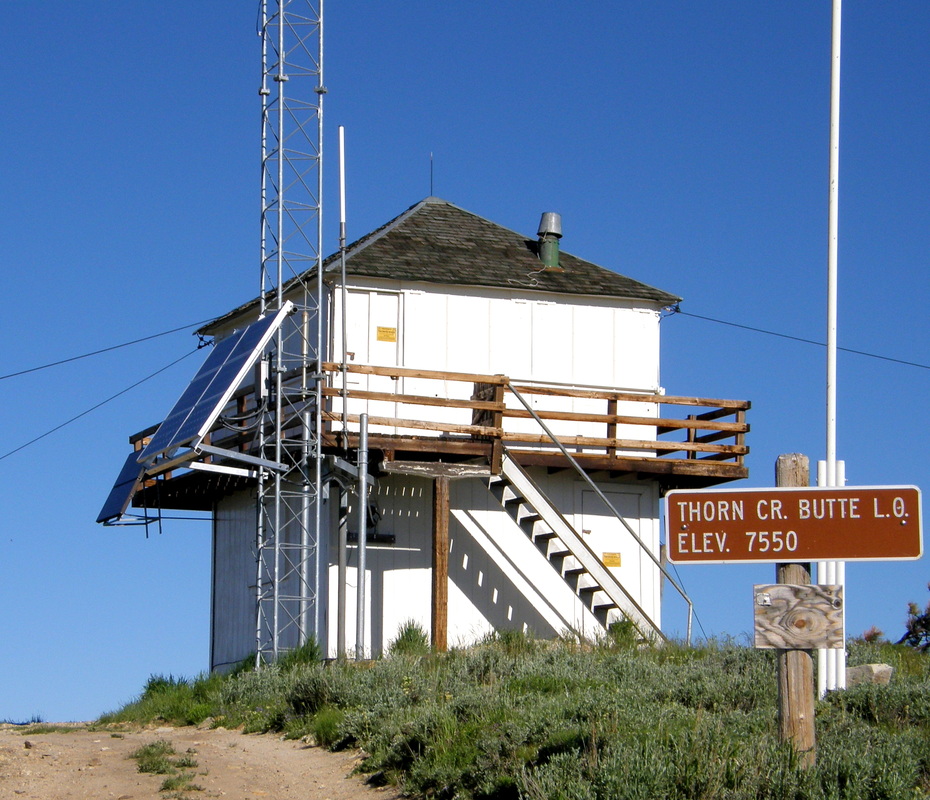
Thorn Creek Butte Lookout Tower is a fire lookout tower located at an elevation of 7,550 feet in Boise County, Idaho. The tower was built in 1933 and has a 10-foot base and an L-4. The summit of Thorn Creek Butte is often staffed during the summer.
The lookout offers 360-degree views of the Mores Creek and Middle Fork Boise River drainages. It also has views of The Trinities, Idaho City, Atlanta, and the Sawtooths.
To reach the road that leads to Thorn Creek Butte, take ID-21 east of Idaho City. The turn is signed for Thorn Creek Butte.
More Information
Coordinates: 43.74470, -115.75160
Elevation: 7480 ft
Difficulty: 3
What to Expect: Expect solid 3+ sections in difficulty
[reblex id=’779′]
Check In
Use the form below to check in. Check-ins must include a photo of you or your bike at the challenge site with the 2024 bandanna. All participants must be registered IAMC Challenge Members. Leave a description of your ride and share road conditions — snow, water, obstacles, and tips for future riders are all appreciated.
Replying to another person's check-in is encouraged, but take care not to accidentally create your own check-in.
The stated difficulty is an estimate. Rating your experience helps future riders stay safe. You alone are responsible for the safety of your ride.
16 Check-Ins
Took NF 203 up a few miles to the rock creek and turned around about 500 ft in and went back to 304 up to the lookout. Much easier!


Nice day for a quick ride out of Boise. Forest Service road 304 goes right to the lookout from HW 21. Still a bit smokey.

I went left when I should have gone right (boy there's a double entendre if there ever was one...LOL!). Seriously though, when I got to the turnaround point at the lookout where I took the picture from, I noticed another road coming up to the top. I took the road that forked to the left (coming up) and it was pretty difficult, especially with a KLR650 parked about halfway up it. I got around the KLR and "sent it" and made it up there with the big bike. I wonder now if the right fork, which leads to a lefthand switchback, was the easier way to go. I may do a dual-sport day up there and see for myself. I wouldn't choose to take my BMW back there though. 3 because I took some unmaintained FS roads to get to the approach to the lookout......the last quarter of a mile (going left) was a 4 though. 2 on the main road (304?) back to Idaho City.


It was getting dark on the way down. the first path we tried was the hard way and is not big bike friendly. We ended up taking the forest road which was easy until the last part where it got a bit dusty.


Typical forest service road. Typical pickup driving on the left around blind corners.

Nice ride to lookout. Someday would like to go back and continue on road past lookout.

I got momentarily disoriented several times between Idaho City and the lookout. I ended up on several trails I had no business on with a 600lb bike! If you stay on the main roads, this challenge point is a level 2, except for the last 500 yards or so, which are level 3+, especially if a young guy on a 2-stroke comes screaming down from the lookout as you are going up.


First time into Thorn Cr Lookout. 304 trail/road is in good condition. Chatted with a couple of Fire Rangers at the lookout. Zoul and lookout attendant were no where to be seen. Great weather!

I have been to Thorn Creek many times this year but not on a bike. I made a route LV5 that would put a little fun and challenge in the ride. You can take 304 up and around which is a maintained dirt road for the most part. The last section at the lookout is an off-camber and rocky part. The dog Zoul will eat your samwhich out of your hand if you are not watching, lol. The lookout attendant is friendly and welcomes visitors. There is a sign at the gate that was up when I arrived. I will upload my GPX file and a video of the last section of the lookout to the forum.
https://youtu.be/U3JxxlFP1P0

I did this ride yesterday via an atv trail (cottonwood creek) that had previously turned me around because it was too difficult for me. Today was total success though. It’s good to see progress in my riding over the years. The beginning of ride was spent crossing and riding in a creek bed. This was right on the edge of my ability alone on the KTM 790 ADV. The road was freshly graded which isn’t my favorite. I like it when it’s rutted lol
Anyone interested in a little different way to access this lookout check out this route
https://www.gaiagps.com/public/Nh2goKqJyyTfWvvOBZDfiYS7

After volunteering for the enduro race in Idaho City my son and I took our bikes up towards Thorne Creek Lookout. I've never been up here, and it was a beautiful ride with mostly well maintained access roads. The last couple of miles jump from 2.5's in difficulty to 3's to 3.5's in difficulty. I probably would not want to bring my larger adventure bike up here. The last 1000 feet or so was snowed in, but we could see the peak so we're calling it. I imagine all of the snow will be gone in a couple of weeks.


Took NF 203 up a few miles to the rock creek and turned around about 500 ft in and went back to 304 up to the lookout. Much easier!
lots of smoke from the Boise foot hill fire
Nice day for a quick ride out of Boise. Forest Service road 304 goes right to the lookout from HW 21. Still a bit smokey.
I went left when I should have gone right (boy there’s a double entendre if there ever was one…LOL!). Seriously though, when I got to the turnaround point at the lookout where I took the picture from, I noticed another road coming up to the top. I took the road that forked to the left (coming up) and it was pretty difficult, especially with a KLR650 parked about halfway up it. I got around the KLR and “sent it” and made it up there with the big bike. I wonder now if the right fork, which leads to a lefthand switchback, was the easier way to go. I may do a dual-sport day up there and see for myself. I wouldn’t choose to take my BMW back there though. 3 because I took some unmaintained FS roads to get to the approach to the lookout……the last quarter of a mile (going left) was a 4 though. 2 on the main road (304?) back to Idaho City.
nice view
Great weather on July 9th. I look forward to doing the ride again.
It was getting dark on the way down. the first path we tried was the hard way and is not big bike friendly. We ended up taking the forest road which was easy until the last part where it got a bit dusty.
nice ride up the hill, got there close to sunset.
Typical forest service road. Typical pickup driving on the left around blind corners.
Nice ride to lookout. Someday would like to go back and continue on road past lookout.
I got momentarily disoriented several times between Idaho City and the lookout. I ended up on several trails I had no business on with a 600lb bike! If you stay on the main roads, this challenge point is a level 2, except for the last 500 yards or so, which are level 3+, especially if a young guy on a 2-stroke comes screaming down from the lookout as you are going up.
Fun ride to Thorn Creek today
First time into Thorn Cr Lookout. 304 trail/road is in good condition. Chatted with a couple of Fire Rangers at the lookout. Zoul and lookout attendant were no where to be seen. Great weather!
I have been to Thorn Creek many times this year but not on a bike. I made a route LV5 that would put a little fun and challenge in the ride. You can take 304 up and around which is a maintained dirt road for the most part. The last section at the lookout is an off-camber and rocky part. The dog Zoul will eat your samwhich out of your hand if you are not watching, lol. The lookout attendant is friendly and welcomes visitors. There is a sign at the gate that was up when I arrived. I will upload my GPX file and a video of the last section of the lookout to the forum.
https://youtu.be/U3JxxlFP1P0
I did this ride yesterday via an atv trail (cottonwood creek) that had previously turned me around because it was too difficult for me. Today was total success though. It’s good to see progress in my riding over the years. The beginning of ride was spent crossing and riding in a creek bed. This was right on the edge of my ability alone on the KTM 790 ADV. The road was freshly graded which isn’t my favorite. I like it when it’s rutted lol
Anyone interested in a little different way to access this lookout check out this route
https://www.gaiagps.com/public/Nh2goKqJyyTfWvvOBZDfiYS7
After volunteering for the enduro race in Idaho City my son and I took our bikes up towards Thorne Creek Lookout. I’ve never been up here, and it was a beautiful ride with mostly well maintained access roads. The last couple of miles jump from 2.5’s in difficulty to 3’s to 3.5’s in difficulty. I probably would not want to bring my larger adventure bike up here. The last 1000 feet or so was snowed in, but we could see the peak so we’re calling it. I imagine all of the snow will be gone in a couple of weeks.
Comments are closed.