12 – Pilot Peak
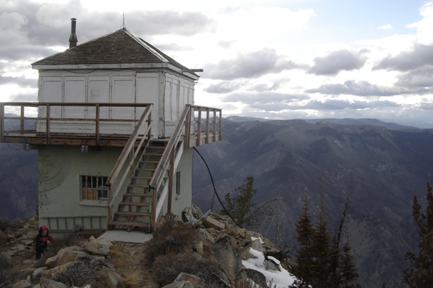
Pilot Peak is a mountain in the Boise Mountains of Idaho, north of Idaho City. It’s a popular destination for outdoor enthusiasts, especially in the winter.
More Information
Links to Additional Info
Coordinates: 43.95981, -115.68660
Elevation: 8100 ft
Difficulty: 3
What to Expect: No Info
[reblex id=’779′]
Check In
Use the form below to check in. Check-ins must include a photo of you or your bike at the challenge site with the 2024 bandanna. All participants must be registered IAMC Challenge Members. Leave a description of your ride and share road conditions — snow, water, obstacles, and tips for future riders are all appreciated.
Replying to another person's check-in is encouraged, but take care not to accidentally create your own check-in.
The stated difficulty is an estimate. Rating your experience helps future riders stay safe. You alone are responsible for the safety of your ride.
15 Check-Ins


Checked this box today, Labor Day. Saw some new fire starts to the south from the lookout, so it worked as advertised. The starts are down around Featherville where I was on Thursday. I rode up the hill from 21, then took 314 down to Idaho City. New roads for me and I echo the sentiments of others.........this Challenge has put me in some places I wouldn't have gone to without it. 314 was very sandy in spots, smooth hard-pack in others. Definitely sees the SxS traffic. The road up from 21 was steep and definitely one lane. I'm glad I rode my 690.


The roughest part of this one was the blind turn off or on the highway. Went up on July 9th.

I came up through Horseshoe Bend to Placerville. Then I went over to Grimes Creek and up over Summit Flats to the Lookout. I went back down Bear Run Road to Idaho City and back to Boise. Nice, fun ride! There were a couple of bad spots on Bear Run Road, but nothing you couldn't ride around.

I rode today with Alex Crane on a 340-mile loop that saw temps as low as 52 degrees and as high as 104 degrees. After you leave the pavement it's not far to the lookout. The road has lots of embedded and a bit of loose rock but isn't too bad.

This was our last stop on our loop. We came up from 21, which is steep and rocky and a solid 3. The road actually improves the further up you go.


They are grading the road, made it a bit loose. Quick 3 miles off the road, easy grab.

Third times a charm. We rode up Summit Flat Rd (380) from Hwy 21 at Mores Creek Summit this time and made it without any issues. Previous attempts earlier this season were unsuccessful due to snow and downed trees. We tried coming up Bear Run from Idaho City and also tried coming in on 380 from the north side out of Garden Valley.
We camped up at the peak since we arrived so late and got to enjoy an amazing sunset. The views are incredible up there.

Attempted from the north in May which would have been the easier route at a 1.5 rating but was stopped by snow. This time we came from highway 21. It was much funner and more difficult. Steep, rocky, and rutty. Fun to flow down. We arrived late in the day and ended up setting up camp on the peak.

Road up to Pilot Peak is clear of snow. Road is in good condition with very few ruts and no washboard. Typical loose over hardpack with usual gravel and rocks.


People working up here today
Checked this box today, Labor Day. Saw some new fire starts to the south from the lookout, so it worked as advertised. The starts are down around Featherville where I was on Thursday. I rode up the hill from 21, then took 314 down to Idaho City. New roads for me and I echo the sentiments of others………this Challenge has put me in some places I wouldn’t have gone to without it. 314 was very sandy in spots, smooth hard-pack in others. Definitely sees the SxS traffic. The road up from 21 was steep and definitely one lane. I’m glad I rode my 690.
you can really see the smoke from up here
Another nice view
The roughest part of this one was the blind turn off or on the highway. Went up on July 9th.
I came up through Horseshoe Bend to Placerville. Then I went over to Grimes Creek and up over Summit Flats to the Lookout. I went back down Bear Run Road to Idaho City and back to Boise. Nice, fun ride! There were a couple of bad spots on Bear Run Road, but nothing you couldn’t ride around.
I rode today with Alex Crane on a 340-mile loop that saw temps as low as 52 degrees and as high as 104 degrees. After you leave the pavement it’s not far to the lookout. The road has lots of embedded and a bit of loose rock but isn’t too bad.
This was our last stop on our loop. We came up from 21, which is steep and rocky and a solid 3. The road actually improves the further up you go.
Came up here after a long day doing a bit of the BDR.
rocky but short climb up to the top.
Another hot summer day for a quick ride. Very smokey
They are grading the road, made it a bit loose. Quick 3 miles off the road, easy grab.
Third times a charm. We rode up Summit Flat Rd (380) from Hwy 21 at Mores Creek Summit this time and made it without any issues. Previous attempts earlier this season were unsuccessful due to snow and downed trees. We tried coming up Bear Run from Idaho City and also tried coming in on 380 from the north side out of Garden Valley.
We camped up at the peak since we arrived so late and got to enjoy an amazing sunset. The views are incredible up there.
Attempted from the north in May which would have been the easier route at a 1.5 rating but was stopped by snow. This time we came from highway 21. It was much funner and more difficult. Steep, rocky, and rutty. Fun to flow down. We arrived late in the day and ended up setting up camp on the peak.
Road up to Pilot Peak is clear of snow. Road is in good condition with very few ruts and no washboard. Typical loose over hardpack with usual gravel and rocks.
Comments are closed.