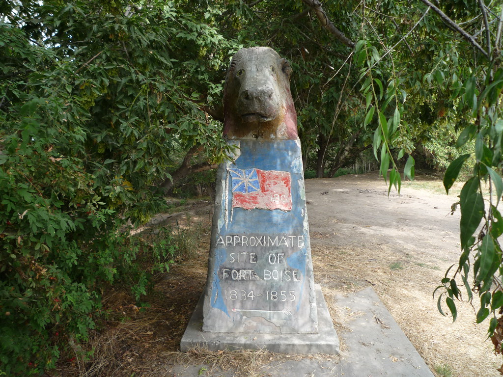
04 – Old Fort Boise Marker
From the FortWIki.com website:
Originally built as fur trading post in 1834 by Thomas McKay as a private venture with an understanding of support from the Hudson’s Bay Company (HBC). It became an HBC post by 1836. The decline of the fur trade caused the post to turn to the salmon fishery as a primary income producer. When the Oregon trail opened in 1841, the post was a major stop for the wagon trains crossing the Snake River into Oregon. The hospitality of the post’s managers to the Oregon Trail travelers was legendary.
Fort Boise was severely damaged in 1853 in a major flood and was just partially rebuilt. Increasing Indian hostilities made it impossible to operate the fort in that location and the post was abandoned in 1854. The U.S. Army established a second Fort Boise (1) in 1863 at what is now the City of Boise, Idaho.
For more information, be sure to check out https://www.hmdb.org/m.asp?m=21992 and http://www.fortwiki.com/Fort_Boise_%282%29
Coordinates: 43.82360, -117.02040
Elevation: 2196 ft
Difficulty: 1-2
What to expect: Well maintained gravel road
Check In
Please read before attempting challenge site or checking in:
Use the form below to check in. Check in’s must include a photo of you or your bike, at the challenge site, with the 2024 bandanna. To check in, all participants must be registered IAMC Challenge Members. Be sure to leave a description about the ride, and share any road conditions as snow, water, or obstacles. Please provide any other information that might help future visitors navigate to this site safely. Replying or commenting on another persons Check In is encouraged, but take care not to create your own Check In on accident.
The stated ride difficulty is just an estimate. By rating the ride difficulty in your experience according to this scale you can help future riders stay safe. You, and you alone are responsible for the safety of your ride. While we do our best to accurately convey the challenge level for each site, it is up to you to make sure you have the skills needed to reach each destination. If you feel the trail exceeds your skill level please turn around immediately.
NOTE: We have been having some issues uploading images. We are working on this. If you are having trouble, try resizing your images to less than 1280×1280 pixels and keep files sizes down to a minimum. If the problem persists, please reach out on the Forums under “Website Tips and Questions.” This should just be a temporary issue as we get the tech figured out. Thank you.
Nice little nature walk past the statue. Easy ride there, road turns to dirt for the last few hundred feet then you park in a lot by the gate to the marmot thing.
As described, a short walk from the gate.
The gate was closed, but the marker is maybe a 100 foot walk from the gate. I visited a few years ago and someone was camped ten feet away from it, and it was becoming overgrown by the trees. They have been clearing the trees away from it and now you can see it from the parking/restroom facilities.
We took backroads from Jump Creek through Homedale, Parma, then on to the Old Fort Boise marker. Stopped once to let a bee out of my helmet. The dairy was quite fragrant today. Roads were dry the whole trip although it looked like it had some nice mud puddles a few weeks ago. The gate was closed so we walked to the monument. I lost count of how many baby cows we startled as we rode by their fields on the way home. Round trip today was a whooping 86 miles, just a few miles until my tiny little gas tank would have needed to be refilled.
I realized I forgot my flag when I was half way there, but I did indeed go. Turns out I gave my flag to another person who had just signed up. If anyone objects we can dual over it. With wooden swords.
The road out there is a 1 until the last quarter mile, where it switches to a 2. There are a few potholes, but even a street bike can manage this location. The Statue is pretty much right on the money for the coordinates.
My guess is a prairie dog, but then again, there are no prairie dogs in Idaho that I know of.
Nice ride outside of Parma. My first time here. River is flowing high at the moment. Good time to check fort Boise.
River running high
Interesting monument. Fortunately for me the road in was dry. Saw a turtle trying to cross the road on the way in.
Last time I was here, I was able to ride right up to the statue of the… Beaver?, Otter?, Dog?, really ugly man?… it was super messy and trashed up back then, so it’s good that they have blocked the path/road to it I suppose to better preserve the area.
Well worth the mud puddles to see this majestic creature.
Well not sure this one counts as I didn’t actually walk over to the marker. I didn’t realize that was there until it was too late lol
Dodging mud puddles to this. I am still not sure what it is, but can say I have seen it.
Never been to the actual site marker, pretty cool.
Accidently added the wrong photo. Not sure how to fix that. Anyway. This was neet to see. Not sure what animal this is supposed to be. It’s a little north of the boat ramp and has had the brush cleared away. We also met another club member that that joined us for the rest of our ride.
It was taller than I expected.
Park at the boat ramp, walk the final 100 yards north, and find the monument on the east bank Snake River.