
12 – Montini Cabin
From OnX Maps:
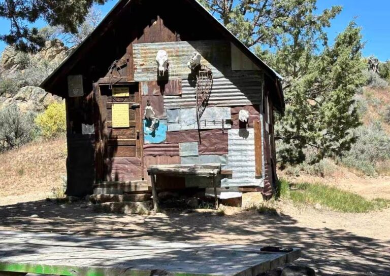
The trail and loop start in the open desert winding through cool rocky landscapes. There are numerous stopping points along the way to enjoy snacks and beverages. The trail is typically hard-packed dirt, with some rocky sections with some light water crossings. There are sections of this loop that climb up into the trees for great scenery. Enjoy the Cabin that is well preserved and is a great stopping point for lunch, there is a nice picnic table with a stream as your backdrop. There are some deeper ruts forming and the landscape does change with the spring run-off, but again, the trail is not too crazy.
More Information
https://www.onxmaps.com/offroad/trails/us/idaho/montini-cabin-homestead-loop#photos
Coordinates: 43.094605, -116.675251
Elevation: 4839 ft
Difficulty: 3
What to Expect: No info
[reblex id=’779′]
Check In
Use the form below to check in. Check-ins must include a photo of you or your bike at the challenge site with the 2025 bandanna. All participants must be registered IAMC Challenge Members. Leave a description of your ride and share road conditions — snow, water, obstacles, and tips for future riders are all appreciated.
Replying to another person's check-in is encouraged, but take care not to accidentally create your own check-in.
The stated difficulty is an estimate. Rating your experience helps future riders stay safe. You alone are responsible for the safety of your ride.
12 Check-Ins

We took the easy road, which was easy on a dualsport, but might be a little trickier on a big bike. There were a few large ruts and a fairly steep downhill section near the cabin. In the pics I've included my gia nav. We took the purple route. The blue one would be difficult on anything other than a dualsport.


This site is a solid 3+, so I wouldn't try it with a big bike. Lots of washouts, rocks, and sand to contend with. It was a blast, however, on the DRZ. Be sure to sign the logbook while you are in there! The map shows how we came in, there are more challenging ways to do it if that is your thing.


Jeez had a rough time with this one. So I posted a marked up map to hopefully help others. The yellow highlighted part really shouldn't be done on a "big bike" unless you for some reason like dragging 600lb bikes up near vertical walls. I'm sure someone could do it but that person was not me. The green highlighted route is the easiest way and starts in the back of Murphy on Old Stage Coach Rd. Bonus info, the blue highlighted part is also a solid 4 depending on bike choice.


I came down from the north east and left out the north west. The ride down was a 3 with one really step part, but the ride out I'd say was a 4 in some spots.

Definitely found the steep way in. Good thing I can pick up this bike by myself. Pretty cool ride though. Stop in and sign the guest book while you're here


What a cool place to visit. Of course, I went in the steep hard way not knowing that if I had taken the road further west, the climb in there would have been a lot easier. The said easier route to the west for the ride out was nice. I regret not dropping a pin at a couple key intersection to help others find the "not so steep" way in.

Timed it perfect. Overnight rain gave good traction and low dust.

The easiest way to get in here is from the old stage coach rd and turn West at the big water tank, and enjoy the ride. a few Mormon crickets are out :}

Pretty challenging site to visit. Lots of rain ruts, rocks, steeps (both up and
down), and sand stone, of which my tires did not want to grab hold of. This is a true “Level 3” site.

Attempted this site today. Wanted to do a loop from Meridian down highway 45 and back on 95 – hit 13 and 2 along the way. Got past the boulder field on Old Wagon Road at the bottom of a big climb a few miles in but lost traction half way up the steep loose bit above the boulders. (see pic) I was solo and decided to abandon the attempt. Will try coming from 95 next time. Not sure I want to ride down that bit again. It can be done but it’s loose and rocky. Not sure how GS riders would do that section. Don’t suggest going solo on this one from 45. Curious to see trip reports entering from 95.

Cool cabin. Love to see old history.
We took the easy road, which was easy on a dualsport, but might be a little trickier on a big bike. There were a few large ruts and a fairly steep downhill section near the cabin. In the pics I’ve included my gia nav. We took the purple route. The blue one would be difficult on anything other than a dualsport.
This site is a solid 3+, so I wouldn’t try it with a big bike. Lots of washouts, rocks, and sand to contend with. It was a blast, however, on the DRZ. Be sure to sign the logbook while you are in there! The map shows how we came in, there are more challenging ways to do it if that is your thing.
Jeez had a rough time with this one. So I posted a marked up map to hopefully help others. The yellow highlighted part really shouldn’t be done on a “big bike” unless you for some reason like dragging 600lb bikes up near vertical walls. I’m sure someone could do it but that person was not me. The green highlighted route is the easiest way and starts in the back of Murphy on Old Stage Coach Rd. Bonus info, the blue highlighted part is also a solid 4 depending on bike choice.
I came down from the north east and left out the north west. The ride down was a 3 with one really step part, but the ride out I’d say was a 4 in some spots.
My route
Definitely found the steep way in. Good thing I can pick up this bike by myself. Pretty cool ride though. Stop in and sign the guest book while you’re here
It rained earlier so a little muddy.
What a cool place to visit. Of course, I went in the steep hard way not knowing that if I had taken the road further west, the climb in there would have been a lot easier. The said easier route to the west for the ride out was nice. I regret not dropping a pin at a couple key intersection to help others find the “not so steep” way in.
Timed it perfect. Overnight rain gave good traction and low dust.
The easiest way to get in here is from the old stage coach rd and turn West at the big water tank, and enjoy the ride. a few Mormon crickets are out :}
Pretty challenging site to visit. Lots of rain ruts, rocks, steeps (both up and
down), and sand stone, of which my tires did not want to grab hold of. This is a true “Level 3” site.
For the record, I went to the parking area on Silver City Road, and went up that way. No snow, but clearly this site is a challenge with or without snow. I did not use HWY 95 to access the site. I also wanted to go from here to Paul’s Baptismal Point, and Wagontown Cemetery, but on that I did run into snow, and had to retreat.
Attempted this site today. Wanted to do a loop from Meridian down highway 45 and back on 95 – hit 13 and 2 along the way. Got past the boulder field on Old Wagon Road at the bottom of a big climb a few miles in but lost traction half way up the steep loose bit above the boulders. (see pic) I was solo and decided to abandon the attempt. Will try coming from 95 next time. Not sure I want to ride down that bit again. It can be done but it’s loose and rocky. Not sure how GS riders would do that section. Don’t suggest going solo on this one from 45. Curious to see trip reports entering from 95.
Comments are closed.