Skip to content

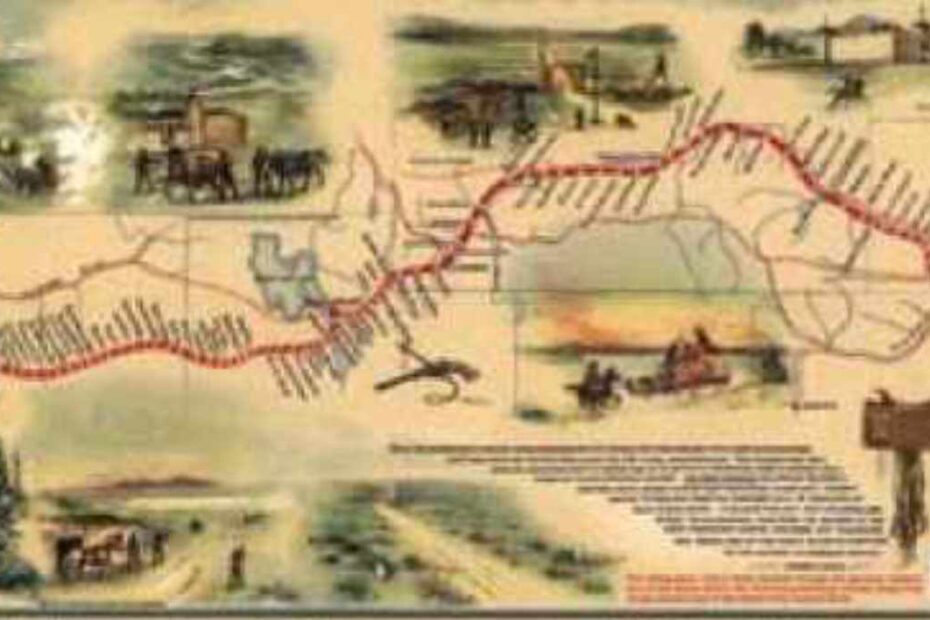
Utah & Wyoming Pony Express Ride

Launched on April 3, 1860, the Pony Express connected California in the far West with the Eastern United States with the fastest means of communication up to that Mme – approximately ten days of hard, fast riding between St. Joseph, Missouri, and Sacramento, California. Though the Pony Express lasted only eighteen months, it became a lasting and endearing legend of the American West. It ceased its operaMons on October 26, 1861, just two days after completion of the transcontinental telegraph that made it obsolete. The last delivery of Pony Express mail arrived in San Francisco

The TransAmerican Trail  

Some roads are fun to ride, some are challenging and some will overwhelm you with scenic beauty but few do all  three like the TAT (Transamerican Trail). 

Dust, Bugs, and Thousands of miles

This last year was challenging for a number of reasons, be it available vaca&on, motorcycle maintenance and opera&on, or my lack of organizational skills and &me management. There were sacrifices made and chances taken, but during the adventures, I was thankful for the opportunity to explore and engage in what our great outdoor world has to offer. My advice, if you see an opportunity or behold an inspiring landscape, take a moment to snap a picture and write a few notes in a journal.

Highlights from the 2015 IAMC Challenge 

The next memorable ride was to Wickahoney Stage Station in south Owyhee County on April 10. Our group of eight riders were “buzzed” by two A-10 Warthogs while at the site. On the way back to Boise, some of our group stopped at Higby Cave located on the Idaho Army National Guard Training Area. It is now gated off near the entrance.

The 2015 Challenge 

I could open up the throttle during the straight-aways but I had to pay extra aPen&on for the sudden dips around the old bridges. During one stretch, a paraglider circled and buzzed us. On their last pass they threw out a streamer weighted with a large washer. I was feeling lucky since I was the first to retrieve it. I just didn’t consider if it was good luck or bad. A while later I found out. 

Summary of the 2015 IAMC Challenge

What constituted a site visit was a photo of the participant and/or the participant’s bike displaying this year’s purple Challenge bandana at one of the op&ons above for each county. Credit for a site visit was only given to those participants who uploaded their photos to the appropriate 2015 Challenge site at motoidaho.org on or before December 31, 2015.

My 2015 IAMC Challenge Adventure

All 44 of the counties in Idaho were now checked off my list but I s&ll had &me for a few more B sites. One of my favorite sites of the year was Indian Lookout in Adams County. The ride in to the lookout along the Little Weiser Road was good gravel road and the smaller Forest Service roads were in good shape until about a mile below the The next morning with temperatures hovering around 36 degrees I was in no hurry to get out of camp. With only Teton County remaining to complete the Challenge, I took my &me riding to the last Challenge site.

Making the Most of the Time I Had – My 2015 Challenge Adventure 

I sat in my office staring at an Idaho map that I have on the wall. It is one of the maps I use for planning, and it was covered with little sticky notes attached to the challenge sites I was planning to visit on my trip. I realized that if I was going to achieve my goal of gold, I had to completely rethink how I was going to accomplish it. I began putting sticky notes up on all of the challenge site locations on the map. Labor Day was in a week. I had a three day weekend that I needed to make the most of. 

GAIA GPS and Off-road Motorcycling 

So sold was I on the obvious superiority of the new technology that I’ve recently joined the company that creates the so[ware I’d been using, Gaia GPS. Some of you probably saw my post about it in our Facebook group. With that background, I hope I can offer tips to evaluate your existing phone or tablet as your adventure GPS device. 

Your Smart Phone or Tablet and Motorcycling

Traditionally, I have used a Garmin GPS (Zumo 550) for my motorcycle navigation. It has worked well for me the past 8 years. Most motorcyclists I know who use a GPS also use a dedicated Garmin or TomTom device. During a recent IAMC GPS Clinic (March 26, 2016) put on by Ron Schinnerer, I had an “aha moment” when David O’Neal discussed the use of smart advices (phones and tablets) as a dedicated GPS device, and he reviewed some of the so[ware apps available for this.