2024 is shaping up to be a great year for riding, and we are excited to re-launch the IAMC challenge. We invite you to get out there this year to see some new sights, visit some old favorite spots, push your limits a little and (most of all) get to better know the great state of Idaho.
Download the 2024 Challenge Sites in GPX Format here:
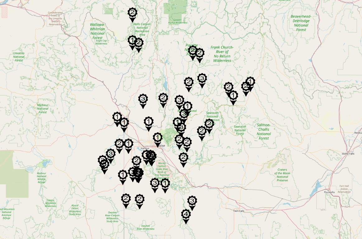
| Number | Location | Coordinates | Elevation (ft) | Difficulty |
|---|---|---|---|---|
| 01 | Jump Creek Falls | 43.47994, -116.92376 | 2593 | 1 |
| 02 | Snake River Birds of Prey Overlook | 43.29791, -116.43377 | 2780 | 2 |
| 03 | Reynolds Creek Cemetery | 43.20247, -116.74916 | 3974 | 2 |
| 04 | Old Ford Boise Marker | 43.82360, -117.02040 | 2196 | 1 |
| 05 | Silver City Cemetery | 43.01924, -116.73471 | 6153 | 2 |
| 06 | Fairview Cemetery | 43.01180, -116.69626 | 7011 | 3 |
| 07 | War Eagle Mountain | 43.00684, -116.70459 | 8025 | 3 |
| 08 | Delamar Cemetery | 43.02390, -116.82662 | 5654 | 3 |
| 09 | Coffeepot Crater | 43.14709, -117.45904 | 4559 | 3 |
| 10 | Birch Creek Ranch | 43.21518, -117.50297 | 2722 | 3 |
| 11 | Thorn Creek Lookout | 43.74470, -115.75160 | 7480 | 3 |
| 12 | Pilot Peak | 43.95981, -115.68660 | 8100 | 3 |
| 13 | Scott Mountain Lookout | 44.18152, -115.78903 | 8157 | 3 |
| 14 | Rocky Bar | 43.68875, -115.28905 | 5262 | 2 |
| 15 | Atlanta | 43.80238, -115.12925 | 5400 | 2 |
| 16 | Doyle Place Cabin | 42.84519, -116.33399 | 4176 | 3 |
| 17 | Dagger Falls | 44.52821, -115.28432 | 5719 | 3 |
| 18 | Paddock Valley Dam | 44.19790, -116.59903 | 3222 | 3 |
| 19 | Slope Road | 43.83811, -116.47580 | 2841 | 1 |
| 20 | Canyon Creek Station Marker | 43.26192, -115.70371 | 3599 | 2 |
| 21 | The Y Stop | 43.50860, -115.62612 | 4639 | 2 |
| 22 | Miner’s Cabin | 43.00490, -116.69926 | 7614 | 3 |
| 23 | Leslie Gulch Boat Ramp | 43.32209, -117.32326 | 2700 | 3 |
| 24 | Succor Creek Mine Shaft | 43.48360, -117.12823 | 2700 | 3 |
| 25 | Custer | 44.38779, -114.69656 | 7074 | 2 |
| 26 | Idaho City | 43.82583, -115.83302 | 3921 | 1 |
| 27 | Lowman Historical Marker | 44.08240, -115.60999 | 3844 | 1 |
| 28 | North Fork Owyhee Campground | 42.59308, -116.98185 | 4797 | 2 |
| 29 | Torrey’s Hole | 44.25571, -114.59419 | 5719 | 1 |
| 30 | Bison Jump Historical Marker | 44.47174, -114.21555 | 5039 | 1 |
| 31 | Bay Horse Ghost Town | 44.39749, -114.31288 | 7071 | 2 |
| 32 | Deadwood City & Mine | 44.46947, -115.58459 | 6003 | 2 |
| 33 | Keeney Pass Interpretive Site | 43.90933, -117.17625 | 2927 | 1 |
| 34 | South Fork Picture Op | 43.55044, -115.78729 | 3818 | 2 |
| 35 | Twin Peaks | 44.59326, -114.47639 | 10312 | 3 |
| 36 | Shoo Fly Pioneer Cemetery | 42.84231, -116.10687 | 2993 | 1 |
| 37 | I Gotta Stop and Pee | 42.58153, -116.67628 | 5200 | 2 |
| 38 | Celebration Park | 43.29942, -116.52275 | 2286 | 1 |
| 39 | Pelota Fronton | 42.97465, -117.05273 | 4410 | 1 |
| 40 | Yellow Pine Pit | 44.92626, -115.33759 | 6254 | 2 |
| 41 | Yellow Pine | 44.96268, -115.49339 | 4773 | 2 |
| 42 | High Valley Guard Station | 44.21263, -116.15307 | 4879 | 2 |
| 43 | Hells Canyon Overlook | 45.12397, -116.83611 | 5557 | 1 |
| 44 | Imnaha | 45.55933, -116.83336 | 1971 | 2 |
| 45 | Cuprum | 45.08568, -116.69669 | 4300 | 2 |
| 46 | Old Wees Ranch | 43.28171, -116.40845 | 2300 | 4 |
| 47 | Indian Hot Springs | 42.33756, -115.64715 | 3698 | 4 |
| 48 | Winter Camp | 42.55367, -115.50555 | 3974 | 3 |
| 49 | Water Crossing | ? | ? | ? |
| 50 | Pick Your Own Site | ? | ? | ? |
| 51 | Kickoff Picnic | 43.55310, -116.56574 | 2501 | 1 |